Date: June 10, 2022
District: Four – Oakland
Contact: Pedro Quintana
Phone: (510) 867-6028
Email: Pedro.Quintana@dot.ca.gov
FOR IMMEDIATE RELEASE
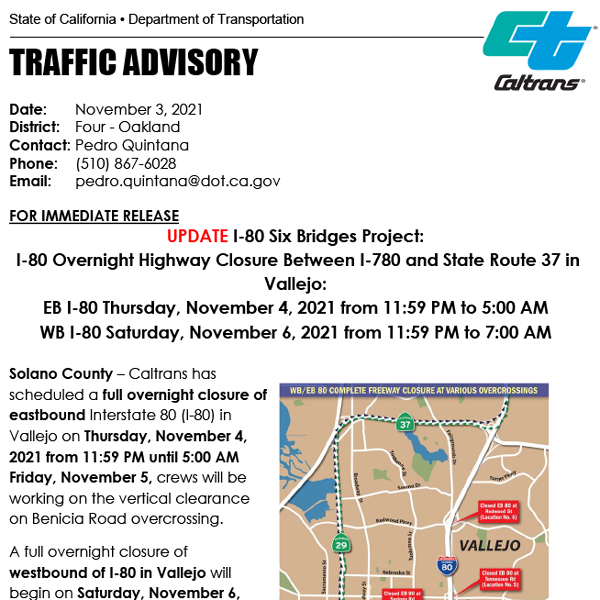
I-80 Six Bridges Project:
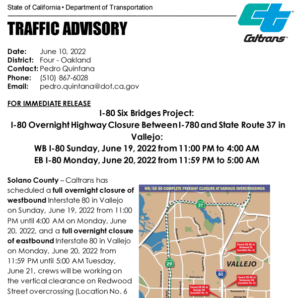
I-80 Overnight Highway Closure Between I-780 and State Route 37 in Vallejo:
WB I-80 Sunday, June 19, 2022 from 11:00 PM to 4:00 AM
EB I-80 Monday, June 20, 2022 from 11:59 PM to 5:00 AM
(I-80 WB/EB to be closed from Red Top Road to I-680 connector ramp)
SOLANO COUNTY – Caltrans has scheduled a full overnight closure of westbound Interstate 80 in Vallejo on Sunday, June 19, 2022 from 11:00 PM until 4:00 AM on Monday, June 20, 2022, and a full overnight closure of eastbound Interstate 80 in Vallejo on Monday, June 20, 2022 from 11:59 PM until 5:00 AM Tuesday, June 21, crews will be working on the vertical clearance on Redwood Street overcrossing (Location No. 6 on the map).
I-80 will be completely closed in one direction at a time for two consecutive nights to raise the bridge spans on Redwood Street overcrossing. A detour will be in place.

During the I-80 closure times, eastbound or westbound I-80 on ramps in Vallejo will be closed as needed to facilitate the work safely.
Detour signs will be posted.
WB/EB I-80 Detours:
Motorists traveling eastbound on I-80 will need to access I-780 to State Route 29 to State Route 37 back onto EB I-80. Motorists traveling westbound on I-80 will need to take State Route 37 to State Route 29 to I-780 to WB I-80.
SHUTTLE SERVICE AVAILABLE:
Phone Number: (415) 263-4000
A 24-hr shuttle service will be available for pedestrians and bicyclists who need to safely cross Redwood Street overcrossing. One shuttle stop will be located on each side of the bridge.
If you have a question or want to share a concern about the project please call the I-80 Six Bridges project hotline (510) 867-6028.
The hotline has been set up for the traveling public and residents living in Vallejo to learn about the most up to date information about the project.
You can also learn more about I-80 Six Bridges project on our Caltrans Bay Area webpage.
Project Webpage: i80sixbridgesvallejo.com
For 24/7 traffic updates, please visit 511.org: https://twitter.com/511SFBay
For real-time information, please visit Caltrans QuickMap: http://quickmap.dot.ca.gov
Or follow Caltrans on Twitter at: https://twitter.com/CaltransD4
#BeWorkZoneAlert
###